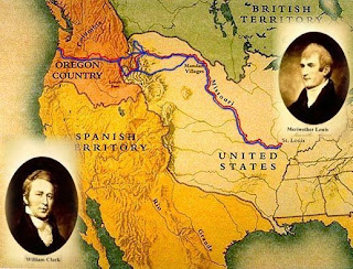
Our Lewis and Clark Google Expedition Project will focus on the journey of Meriwether Lewis and William Clark across the American West. Lewis and Clark were chosen by President Thomas Jefferson to explore the land that was bought from France during the Louisiana Purchase; this area at the time was called the "Lousiana Territory".
Their main goal was to discover a water route that connected the Atlantic and Pacific Oceans in order to encourage American westward expansion. One of their other goals was to document the unknown peoples, geography, plants and animals of the western United States
Your goal for this project will be to create a collaborative map with your classmates of Lewis and Clark's expedition. You will be learning about how the expedition came about, what happened during their journey and why their journey was so important to the expansion of the United States.
In order to complete your project, you will be using 2 Google services, Google Docs and Google Maps. Google Docs will allow you to create a Word document online where you will answer several questions and include all of your research for your project. Google Maps will allow you to create a collaborative map of their expedition, which will include many of the points that they stopped at, information on what happened there and images that relate to that point on the map.
What do you already know about the Louisiana Purchase and the Lewis and Clark Expedition? Please COMMENT to this post.


